The US state of Utah (UT) is located in the western part of the US. Geographically, Utah has three major areas: the Rocky Mountains in the northeast, the Great Basin in the west and the Colorado Plateau in the southeast. The basin and range topography in the west means that precipitation has relatively little chance of reaching the low-lying plains, creating a dry desert climate. The combination of a desert climate with large salt flats provides a wonderful testing ground for car manufacturers to try out new models. The hot, dry summer months are especially suitable for exposing cars to all kinds of harsh tests.
Within the rest of Utah you will find a combination of a cold steppe climate, very locally a warm steppe climate and a mix of various continental climates where there is a fairly large contrast between the coldest winter months and the warmest summer periods. Utah has some great ski resorts that are especially popular because of the excellent quality of the snow. Very dry and quite large snowflakes make for an almost perfect snow cover for skiing or snowboarding. The large variations that can occur in Utah within a calendar year are mainly seen in the extremes measured here. For example, there is near St. Georgea record maximum of 48 degrees Celsius was measured, while the sinkhole Peter Sinks set a record depth of no less than -56.3 degrees Celsius on February 1, 1985.
Climate figures
The figures below are based on long-term average climate statistics. The temperatures are displayed in degrees Celsius (°C).
| maximum temperature | minimum temperature | hours of sunshine per day | days of rainfall per month | |
| January | 2℃ | -8℃ | 4 | 9 |
| February | 6℃ | -5℃ | 6 | 8 |
| March | 11℃ | -1℃ | 8 | 10 |
| April | 16℃ | 2℃ | 9 | 9 |
| May | 22℃ | 7℃ | 10 | 8 |
| June | 28℃ | 12℃ | 12 | 6 |
| July | 33℃ | 16℃ | 13 | 5 |
| August | 31℃ | 15℃ | 12 | 7 |
| September | 26℃ | 9℃ | 10 | 6 |
| October | 19℃ | 3℃ | 8 | 6 |
| November | 10℃ | -2℃ | 5 | 8 |
| December | 3℃ | -7℃ | 4 | 9 |
The climate of Arches National Park
Lovers of rock formations, natural bridges and balancing rocks will find what they are looking for in Arches National Park. This special area covers an area of more than three hundred square kilometers and is located near the city of Moab in the American state of Utah. Several natural elements have contributed to the creation of the many arches that you can admire in Arches National Park. Water and wind erosion have done important parts of the work over a period of some three hundred million years. Ice and tectonic activity have also played their part. Notable landmarks within Arches National Park include the Delicate Arch, the Balanced Rock, the Landscape Arch, and the Double Arch.
Arches National Park has a cold steppe climate (BSk climate). The contrasts in the weather between summer and winter are quite large: snow and night frost are normal during the coolest months, while the summer months are sweltering, with maximum temperatures averaging around 40 degrees. It is striking that the chance of precipitation is quite limited. The annual precipitation sum is on average around 220 millimeters. Precipitation often falls in the form of rain, but in the period November to March it can also snow in Arches National Park. During the day, the snow often rushes due to the temperatures that are usually well above freezing.
Heat
Due to the heat in the summer, spring and autumn are the best time to visit Arches National Park. Due to the longer summer holidays, many Dutch people still choose to travel to this special place during the hottest months (July and August). It is then perfectly bearable in the air conditioning of the car when the mercury moves towards the usual 35 to 40 degrees. As soon as you go for a walk, you will notice the heat. Despite the fact that the relative humidity in Arches National Park is fairly low and it is therefore less stuffy, you lose quite a bit of moisture during a walk. Therefore, take plenty of drinking water with you during your hikes through the Arches National Park.
The climate of Blanding
Blanding is a town located in the southeastern US state of Utah. Due to its proximity to two Native American reservations (Navajo and White Mesa Ute), there is a fairly large Native American presence among the Blanding locals. Often they are relatives of one of the aforementioned tribes. Blanding is a popular stopover among those touring Utah. The town is on a popular route to several natural areas and attractions, such as Canyonlands National Park, the Dinosaur Museum and the Natural Bridges National Monument.
Blanding has a cold steppe climate or a BSk climate. The word ‘cold’ should not be taken too literally. It is an indication to indicate the difference with the warm steppe climate. If you look at Blanding’s climate statistics, you will discover that this place, with an average annual daily temperature of 17.8 degrees Celsius, remains just below the limit of 18 degrees.
The winters are on the cool side in Blanding. The altitude of 1,861 meters above sea level ensures that it can cool down considerably in winter: on average maximum temperatures are around 5 to 7 degrees above zero. Moderate frost at night is quite normal. Sometimes it can even come to severe frost. In the spring, the average temperatures rise considerably, and in the summer they eventually reach an average maximum of around 30 degrees.
Precipitation is limited in Blanding. The average annual sum is 330 millimeters. It snows regularly in winter: about 95 to 100 centimeters of snowfall per year is normal. The months of December and January offer the greatest chance of snow. Spring and summer are generally the driest. May and June yield hardly any significant precipitation. In the following months, a summer rain shower can be accompanied by heavy thunderstorms.
The climate of Bryce Canyon City
Bryce Canyon City is a village in the US state of Utah. Bryce Canyon City, also referred to simply as Bryce on maps, may be seen as the gateway to Bryce Canyon National Park. The town consists of accommodations supplemented with restaurants and shops. The overnight tourists stay here with the aim of being close to the national park. That way you can hit up all your favorite spots in Bryce Canyon National Park in the morning before the crowds. During the summer months, the hotels and motels of Bryce Canyon City are very busy. It is therefore advisable to book in time, especially for the period from 4 July.
Bryce Canyon City has a temperate continental climate with warm summers. Within the Köppen climate system we are talking about the Dfb climate. What is striking are the fairly large contrasts that can occur in the weather in all kinds of ways. Think of icy winter nights versus sometimes sweltering summer days, but also large temperature differences within 24 hours. Especially in the spring and autumn there can be quite a big difference between the minimum and maximum temperatures in Bryce Canyon City. This is partly due to the altitude of the place: 2336 meters above sea level.
Precipitation falls in Bryce Canyon City throughout the year. This happens in fairly limited quantities. The summer month of August is slightly wetter due to the summer rain and thunderstorms. In the winter season there is regular snow. The average maximum temperatures in winter are several degrees above zero. During the year, these average maxima rise to about 25-27 degrees during the hottest months. Then there can be tropical days, with afternoon temperatures of more than 30 degrees.
The Climate of Bryce Canyon National Park
Bryce Canyon National Park is one of the most beloved national parks in the US. Within the American state of Utah, this beautiful nature reserve, together with Zion National Park, is one of the absolute tourist highlights. Bryce Canyon can count on approximately three million visitors every year. Bryce Canyon National Park is known for its unique geological rock formations. Erosion as a result of freezing and thawing has resulted in the formation of so-called hoodoos. (earth pyramids). The different colors in the rock layers, together with the sunlight, create a magical effect.
Within the Köppen climate system, Bryce Canyon National Park has a moderate continental climate. This continental climate type is characterized by highly variable weather conditions during autumn, winter and spring. If you look at the climate statistics of Bryce Canyon, you will see that there are no less than 3750 hours of sunshine per year, that the annual precipitation sum is on average around 425 millimeters and that the average annual daily temperature is just below 7 degrees Celsius.
During the warmer summer period, sudden heavy summer rain and thunderstorms can occur. Especially in the months of July and August, you have to take into account quickly developing showers during your walks through the park, which can surprise you quite a bit. That chance is greater in the afternoon than in the morning. August is the wettest month in Bryce Canyon National Park, with a monthly precipitation sum of about 50 millimeters and an average of ten days with some precipitation
Snow
A layer of snow may make the rock formations in Bryce Canyon National Park even more beautiful than when there is no snow. The first snow showers can fall as early as October. It snows regularly from November to March. On an annual basis, snow falls for about 30-35 days, which gives a total of about 225 centimeters of snowfall.
Temperatures
Temperatures in Bryce Canyon National Park vary widely. Due to the altitude, the heat in the summer often remains limited. The average maximum temperatures in summer are between 23 and 26 degrees. During the winter months you have to count on maximums that are on average a few degrees above freezing. During the night there is often moderate or even severe frost. The coolest nights can have minimums that fall below the freezing temperature.
The Climate of Canyonlands National Park
Canyonlands National Park is one of the most pristine natural areas in the US state of Utah. The landscape mainly consists of canyons and table mountains, where there is hardly any serious vegetation. As a result, the character of Canyonlands National Park is decidedly desolate, although there are several animal species such as the coyote, the fox, the skunk and the bighorn sheep. Among the wild animals that occur here is also the black bear, but it is less and less often spotted in this area.
The geographic location of Canyonlands National Park provides an arid climate, creating a kind of desert landscape. The official climate of Canyonlands National Park is the cold steppe climate (BSk climate) with locally a warm desert climate (BWh climate) or a cool desert climate (BWk). The amount of precipitation determines where there is a desert climate instead of a steppe climate. The average annual temperature makes the difference between the warm and the cold desert climate. The standard here is higher or lower than 18°C. The long-term average is often around this value.
Temperatures
Within Canyonlands National Park there are quite large contrasts in temperature. In the summer months the maximum temperatures are usually between 30 and 35 degrees, while the minimum temperatures are between 15 and 20 degrees. In winter the maximums are often between 0 and 10 degrees and the mercury drops below freezing at night. Light to moderate frost is common during the winter nights, but there are also nights when it is severely freezing in Canyonlands National Park. In spring and autumn, extreme temperature differences can occur within 24 hours. Summer values of 25 degrees during the day can then be accompanied by frost at night.
Precipitation
You don’t have to count on very much precipitation when you visit Canyonlands National Park. On an annual basis, the average precipitation is limited to 200-250 millimetres. Extreme rainfall or heavy snow storms are uncommon here. The number of days per year that more than 10 millimeters of precipitation is recorded is limited. In total, there is some precipitation for about 50 to 60 days a year. In winter this can be in the form of snow. Canyonlands National Park receives an average of 30 to 40 centimeters of snow per year.
The climate of the Capitol Reef National Park
The Capitol Reef National Park is a national park that is located fairly centrally in the US state of Utah. The shape of the area is striking: the park is almost 100 kilometers long and on average less than ten kilometers wide. This is because the Capitol Reef National Park is situated around a large fold in the earth’s crust: the Waterpocket Fold. The park includes a variety of attractions, such as domed rocks, gorges, arches, sand dunes and many different colors, which are created by the different stone and sand layers. There are hardly any paved roads through the Capitol Reef National Park. Utah State Route 24 is the only paved thoroughfare that cuts right through the park.
The Capitol Reef National Park has a cold steppe climate. This semi-arid climate type is referred to as a BSk climate within the climate system devised by Köppen. The low amounts of precipitation create a barren and dry landscape, which often causes a lot of dust while driving on the unpaved roads. If you want to visit the Capitol Reef National Park with a rental car with an open roof, it is better to close the roof during the rides on these trails. It also protects you in the summer months against the bright sun and the resulting high temperatures.
On an annual basis, the Capitol Reef National Park receives an average of 180 to 240 millimeters of precipitation. It depends a little bit on where exactly you are in the park. In winter, temperatures are around 5 to 10 degrees during the day, while at night it often freezes slightly to moderately. In December, January and February severe frosts regularly occur during the night hours. In the summer it is a lot warmer in the Capitol Reef National Park. The maximum temperatures are often between 28 and 34 degrees, sometimes it gets a little warmer. After sunset, it also cools down quite quickly in the summer months. Its location inland, in combination with the often clear air, ensures that the minimum temperatures during the hottest months are often well below 20 degrees.
The Climate of Dead Horse Point State Park
Dead Horse Point State Park is a state park in the US state of Utah. The park encompasses part of the Colorado River basin. This river meanders through the Colorado Valley, which was created by water erosion. The highlight of the park is Dead Horse Point. This is a viewpoint that offers a beautiful panoramic view of a winding part of the valley. The barren rocky landscape with the green river creates an almost surrealistic picture. Good to know is that the entrance to Dead Horse Point State Park is not included in the annual pass for the national parks of the United States. You have to pay a separate entrance ticket here at the toll gate. It is also useful to ensure that you have sufficient fuel, water and any other provisions before entering the park. You can’t buy anything in the park,
The dry weather conditions combined with the temperature pattern mean that Dead Horse Point State Park has a cold desert climate. On an annual basis, less than two hundred millimeters of precipitation falls. The desert landscape therefore has little vegetation. Still, this place provides enough resources for some wildlife to survive in the wild, including rattlesnakes.
In the summer months it gets sweltering in Dead Horse Point State Park. The average maximum temperatures in July and August rise to about 35 to 40 degrees. It often gets a little warmer. Fortunately, you can reach the viewpoint by car, eliminating the need for a strenuous walk under the blazing sun. In the spring and autumn, the weather in the state park is a lot friendlier. It is then mainly sunny, often dry and above all pleasantly warm, with afternoon temperatures often somewhere between 18 and 28 degrees in April/May and often above 20 degrees in October.
Thunderstorms can sometimes occur in Dead Horse Point State Park during the summer. Due to the very limited possibilities for shelter and the large open spaces, it is advisable to stay in the car during thunderstorms. Outside the car during thunderstorms is just too dangerous.
The climate of Escalante
Escalante is a village in the US state of Utah. Escalante is not much in terms of size and population: the town has less than a thousand inhabitants. Escalante is important for tourists who make a tour through Utah. The village is a frequently used stopover where fuel is refueled, shopping is done or where people spend the night. After all, Escalante is located along one of the more beautiful highways through the United States: the Utah Scenic Byway 12 (SR-12). Furthermore, Escalante is located on the north side of the Grand Staircase-Escalante National Monument. This over 7500 square kilometer area has various geological attractions such as canyons, rock formations and colorful terraces.
Escalante has a cold steppe climate. This BSk climate is characterized by little precipitation, an average annual temperature below 18 degrees Celsius and warm summers. The temperature difference between summer and winter is significant. In addition, you see that there are reasonable differences between the highest and lowest temperatures within 24 hours. In the spring, for example, the maximum temperature can exceed the summer limit of 25 degrees while it freezes at night.
The average annual precipitation sum in Escalante is around 275 millimeters. It often concerns rain, but in the winter period snowfall is quite possible. You can count on an average of 60 to 80 centimeters of snow in Escalante every year. The greatest chance of winter precipitation is in December and January. In February you can already see the snow chances decrease.
The climate of Mexican Hat
Mexican Hat can mean two places in Utah: the village that lies along the San Juan River or the rock formation slightly further away. These rocks are known as the Mexican Hat Rock, due to the fact that the whole thing looks like a sombrero (typical Mexican hat) on the rocks. The village of several dozen inhabitants is named after this famous rock formation. Fun fact is that the name ‘Mexican Hat’ regularly appears in lists of unusual or special place names.
The arid red landscape around Mexican Hat is mainly due to the dry climate that prevails here. Based on the annual precipitation sum, Mexican Hat has a cool desert climate (BWk climate). Some sources believe that there is a cold steppe climate (BSk climate) here, but there is just too little precipitation. On an annual basis you can count on approximately 190 to 200 millimeters of precipitation in Mexican Hat. Most of it comes in the form of rain that has fallen from the sky. During the relatively cool winters it can snow. It does this on average four days a year, which produces a total of about 20 centimeters of snow.
The temperatures underline the erratic nature of the weather in Mexican Hat. In the summer heat is quite normal, while in the winter it can get quite cool. During the hottest months, the mercury easily rises to values around 35 degrees during the day. Very occasionally the limit of 40 degrees is reached. Fortunately, you don’t have to get out of the car to see the Mexican Hat Rock. If you want to, you can get closer to the rock formation via hiking trails.
The climate of Moab
Moab is a small town in eastern Utah, in Canyon County. The village is very popular with tourists, especially because of the many parks that can be found around the village. The Arches National Park with the famous Delicate Arch is located here. This 16-foot-tall arch is one of the most famous arches in the world and one of Utah’s top tourist attractions. Especially the outdoor sports, such as mountain biking, rock climbing, rafting and kayaking, are very popular here. Nearby you can rent 4×4 cars to traverse the area.
Moab has a cold steppe climate, with little rainfall throughout the year. The winter months are cold, with long periods of frost and night frost. During the summer months, the sun is in the sky here for a long time. As a result, the temperature during these months is well above 30 degrees Celsius. There is so little rainfall here that Moab shows symptoms of the cold desert climate.
The climate of Saint George
Saint George is a large city in the southwest of the US state of Utah. Saint George is located in Washington County, not far from the borders with the states of Nevada and Arizona. Las Vegas is less than 200 miles from here. The city was founded in the second part of the 19th century by Mormon pioneers. Today, Saint George is often the starting point of a journey through Utah’s colored landscape. One of the most beautiful buildings in the city is the St. George Utah Temple. This church was built by the Church of Jesus Christ of Latter-day Saints, also known as Mormons for short.
Saint George has a cold steppe climate, with little to no precipitation during the year, but just a little too much for the cold desert climate. Due to the southwestern location of the city, the average temperatures here are a lot higher than in the more northerly places in Utah. The average annual temperature is slightly above 16 degrees Celsius, which is just too little for the warm steppe climate. The summer months are quite warm, with average temperatures just below 40 degrees Celsius.
The climate of Salt Lake City
Salt Lake City is the capital of the US state of Utah. This largest city in Utah is located in Salt Lake Valley, a large valley of no less than 1,300 square kilometers. Salt Lake City gets its name from its location on a huge salt lake, Great Salt Lake. This huge lake owes its high salinity to the fact that no water runs off to the sea. Due to evaporation, the salt present remains behind, which causes the salt content to increase further and further.
Salt Lake City has a cold steppe climate (type BSk according to the Köppen climate classification), with moderately cool winters, short transitional seasons and a fairly long, warm summer. With over 3,000 hours of sunshine, Salt Lake City is one of the sunniest cities in the US. In the month of July, the sun shines an average of 12.7 hours per day. Rain is also relatively rare in this – warmest – month of the year. Precipitation is recorded for five days, with the average monthly total for July limited to just 16 millimeters.
The climate of Springdale
Springdale is a village in the southwestern US state of Utah. Springdale owes its existence almost entirely to the fact that it is located at the entrance to Zion National Park. Although the town itself has less than a thousand inhabitants, it can be called lively. This is due to the presence of often thousands of tourists, who come here because of the Zion National Park. Here you can spend the night, eat, drink and do some shopping. Due to the limited parking capacity in the park itself, many tourists park their car in Springdale, and then use the shuttle bus to visit the park.
Springdale has a cold steppe climate (BSk climate). This climate type is a so-called semi-arid climate. It is mainly the annual precipitation sum that is decisive. In Springdale’s case, it averages 350 to 400 millimeters. The months of January, February and March are a bit wetter. The spring months (April and May) are the driest in Springdale. The low amounts of precipitation, combined with the somewhat subdued temperatures, make April and especially May very popular to visit Springdale. It can get seriously hot in the summer. The maximum temperatures are then on average around 33 to 37 degrees. During the hotter days, the mercury can rise above 40 degrees.
The winter months are significantly cooler. During the day it is often between 10 and 15 degrees, while the minimum temperatures are around or just below freezing. Precipitation can fall in the form of snow during the nighttime hours. During the day there is more rain than snow. Watch out in the morning for the difficult to see slipperiness that can arise from freezing road sections. Both spring and autumn can be very variable in terms of temperatures. Both very warm days and cool nights are then possible. Sometimes the temperature difference increases to 25 degrees or more within 24 hours.
The climate of Vernal
Vernal is a small town in northeastern Utah, in Uintah County, on the Green River. Vernal is located on the foothills of the Rocky Mountains, at about 1,600 meters altitude in the Uinta Mountains. This mountain range forms the border between the states of Colorado and Utah. The Dinosaur National Monument is located in this mountain range. There are several game reserves around Vernal, such as the Browns Park National Wildlife Refuge and the Ouray National Wildlife Refuge.
Vernal has a cold steppe climate, with very little precipitation throughout the year. The precipitation figures are just a bit too high for a cold desert climate. During the winter months there are long periods of frost. The nights in particular can be bitterly cold. During the summer months the mercury rises considerably and temperatures well above 30 degrees Celsius are certainly no exception.
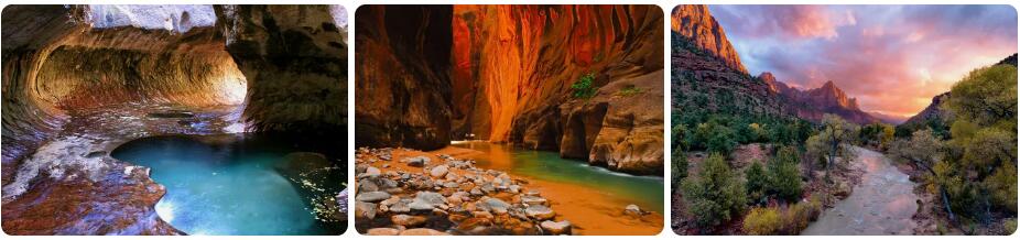
The climate of Zion National Park
There are no fewer than five national parks in the American state of Utah. The most visited of these five is Zion National Park. This wildlife sanctuary is located in southwestern Utah. Its Biblical name comes from the Mormon pioneers who have lived in large numbers in Utah since the 1800s. Zion National Park is considered one of the best national parks in the US due to its diversity of natural phenomena. It is not for nothing that approximately four million visitors visit the park every year. During the busier periods, most of the park can only be visited by shuttle bus. This is due to the limited road and parking capacity. Most people park their cars in the nearby village of Springdale.
Zion National Park has a cold steppe climate. This climate type is referred to as a BSk climate within the Köppen climate system. In the case of Zion National Park, this semi-arid climate has an average precipitation sum of 410 millimeters per year, an average annual daily temperature of 16.8 degrees and quite a few extremes in temperatures. For example, maximum temperatures can reach well above 40 degrees and it can freeze twenty degrees at night in winter. These are extremes that do not belong to the usual circumstances. This does not alter the fact that the summer months can certainly be called hot during the day and that night frost is quite common in winter. The average maximum temperatures in Zion National Park in June, July and August are usually between 35 and 40 degrees. It is not for nothing that spring and autumn are considered the best time to travel to Zion. Especially for strenuous walks it is more pleasant when it is less hot.
Precipitation
Zion National Park is a semi-arid destination. It rains on average a few days a month, Zion does not have really wet months. Precipitation is fairly spread out over the calendar year. The precipitation statistics show a slightly higher precipitation sum in January, February and March. May and June are somewhat drier than average. In winter there is a chance that precipitation will fall in the form of (wet) snow. These are rarely serious quantities. In an average year, a total of about ten centimeters of snow falls. This often falls at night and the snow melts during the day due to the higher temperatures.